Satellite Tagging of Olive Ridley Turtles for Coastal Conservation

Two-year telemetry study tracks nesting, migration, and fishing interactions along Tamil Nadu coast
SuryaSurya
4 mins read
Satellite-tagged Olive Ridley turtle released for conservation study
Not Started

1. Context: Marine Turtle Conservation and Scientific Monitoring

Marine turtles, including the Olive Ridley, are migratory species whose survival depends on safe nesting beaches and undisturbed marine corridors. India’s long coastline makes it a critical habitat, but increasing coastal development and fishing pressures have intensified conservation challenges.

The article highlights a first-of-its-kind initiative on city beaches where Olive Ridley turtles were satellite-tagged during nesting. This marks a shift from reactive conservation to proactive, data-driven wildlife management using modern technology.

Such initiatives are significant for governance because marine biodiversity conservation is closely linked with sustainable fisheries, coastal livelihoods, and India’s international environmental commitments. If scientific monitoring is ignored, conservation policies risk remaining generic and ineffective.

The governance logic lies in recognising that migratory species cannot be protected through static rules alone; without spatial and temporal data, regulatory responses remain misaligned with ecological realities.

2. Issue: Knowledge Gaps in Turtle Movement and Human Interaction

A key issue addressed is the limited understanding of turtle movement in near-shore waters during nesting seasons. Traditional conservation relied heavily on beach protection, leaving marine-phase threats insufficiently studied.

The study aims to monitor behaviour, nesting patterns, and interactions with fishing activities between November and April. This period is critical as it coincides with intense fishing activity along the Tamil Nadu coast.

Without such monitoring, accidental injuries from fishing gear and habitat overlap remain under-documented, weakening both conservation enforcement and conflict mitigation with fishing communities.

Effective governance requires identifying where and when conflicts occur; absence of such evidence results in regulatory blind spots and reactive enforcement.

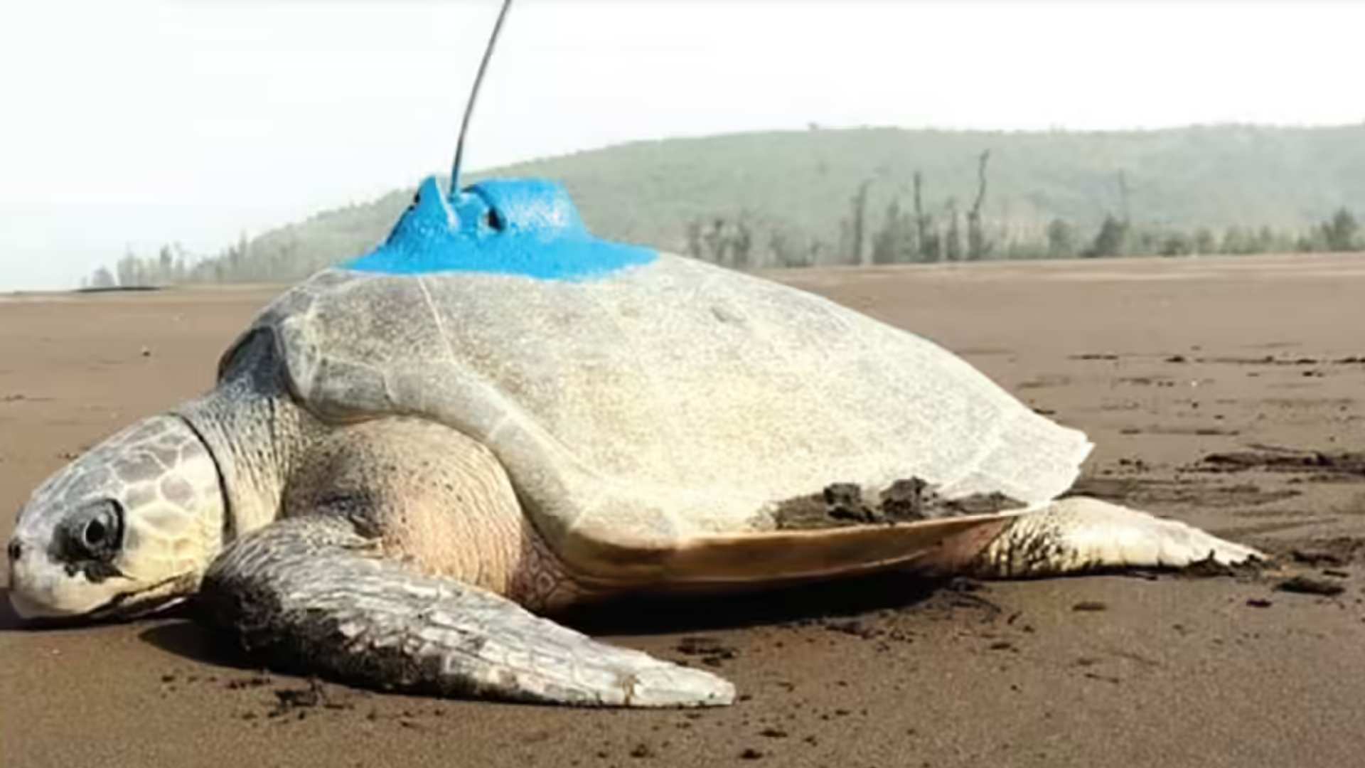
3. Instrument: Satellite Tagging and Telemetry Technology

Satellite tagging allows continuous tracking of turtles across marine and coastal zones, providing near real-time data on movement and habitat use. Flipper tagging complements this by enabling long-term identification and nesting-site fidelity analysis.

The article notes that tags will be deployed across vulnerable nesting sites, including the Chennai coast and the Cauvery delta. This ensures spatially diverse data rather than site-specific assumptions.

Such technology strengthens conservation by shifting focus from anecdotal evidence to empirical datasets, enabling adaptive policy responses. Ignoring technological tools risks outdated management in a rapidly changing coastal environment.

The logic is that technology converts conservation from intent-based to evidence-based governance; without it, policy remains static despite dynamic ecosystems.

4. Institutional Framework and Coordination

The initiative is carried out jointly by the Wildlife Institute of India and the Advanced Institute for Wildlife Conservation, with support from the Tamil Nadu government through a formal Government Order issued in August 2025.

This reflects institutional coordination between research bodies and state administration, a critical requirement for environmental governance under India’s federal structure. Veterinary support from Arignar Anna Zoological Park further demonstrates multi-agency involvement.

Weak coordination often leads to fragmented conservation outcomes. In contrast, institutional collaboration enables integration of research findings into policy and field-level implementation.

Governance effectiveness depends on institutional convergence; without it, scientific findings fail to translate into regulatory or operational action.

5. Wildlife Health, Ethics, and Conservation Practice

One tagged turtle required surgical removal of a fishing hook before release, highlighting the intersection of wildlife health management and conservation objectives. Veterinary intervention ensured the turtle’s survival and ethical treatment.

Such instances reveal the hidden costs of marine resource use and underline the need for humane wildlife response mechanisms within conservation frameworks.

If animal welfare is neglected, conservation efforts lose legitimacy and may face resistance from both communities and enforcement agencies.

Ethical wildlife management strengthens conservation credibility; ignoring it undermines trust and long-term compliance.

6. Implications for Coastal Governance and Policy

The study has wider implications for regulating fishing practices, designing seasonal advisories, and protecting critical marine habitats. Data on turtle–fishing interactions can inform gear modification and spatial restrictions.

Impacts:

  • Improved identification of conflict zones between turtles and fisheries
  • Evidence-based refinement of coastal conservation measures
  • Enhanced compliance through scientific justification

Failure to integrate such findings into policy would perpetuate biodiversity loss and regulatory inefficiency.

Data-driven insights enable balanced governance; without policy uptake, scientific efforts remain academic.

7. Way Forward: Strengthening Science–Policy Linkages

Long-term conservation requires institutionalising telemetry studies, expanding them to other coastal states, and integrating findings into fisheries and coastal regulation frameworks.

Capacity-building of local enforcement agencies and awareness among fishing communities will be essential to translate data into action.

Sustained investment in scientific monitoring ensures resilience of conservation policies in the face of climate change and coastal pressures.

The way forward lies in embedding science within governance systems; ignoring this risks reactive and fragmented conservation outcomes.

Conclusion

The satellite tagging initiative represents a shift towards evidence-based marine conservation in India. By aligning technology, institutions, and policy, it strengthens coastal governance while safeguarding biodiversity. In the long term, such approaches are essential for sustainable development and ecological security.

Quick Q&A

Everything you need to know

The primary objective of the satellite-tagging initiative is to strengthen conservation efforts for the vulnerable Olive Ridley sea turtle through advanced monitoring of their movements and behaviour. The study, conducted from 2025 to 2027, aims to track nesting patterns, migratory routes, and interactions with human activities, particularly fisheries.

By deploying satellite and flipper tags, researchers can collect high-resolution data on turtle behaviour in near-shore waters, which is crucial for informed decision-making and targeted protection measures. The initiative is also intended to guide future policy interventions, such as protecting key nesting beaches, mitigating human-induced threats, and improving overall species management strategies.

The monitoring system combines satellite tagging and flipper tagging to provide both real-time and long-term insights into turtle behaviour. Satellite tags, attached to the turtle’s carapace, transmit hourly location data, allowing researchers to map migratory routes, identify foraging grounds, and track near-shore movements during nesting season from November to April.

Flipper tags serve as a long-term identification tool, helping track individual turtles over multiple years and understand nest-site fidelity. For instance, researchers can determine whether a turtle returns to the same nesting beach each season. Together, these methods allow scientists to evaluate ecological patterns, assess the impact of threats such as fishing hooks, and implement site-specific conservation interventions.

Telemetry-based monitoring is crucial because Olive Ridley turtles face numerous anthropogenic threats, including accidental capture in fishing gear, habitat loss, and coastal pollution. Satellite data enables continuous tracking, which helps authorities take timely action to protect turtles and their habitats. For example, one of the turtles tagged in this study had a fishing hook lodged in its mouth and required veterinary intervention before release. The tag ensures researchers can monitor its post-release recovery.

Additionally, telemetry provides scientifically robust data on migratory corridors, nesting grounds, and foraging zones. This allows policymakers to implement evidence-based interventions, such as establishing Marine Protected Areas (MPAs), regulating coastal fishing activities, and protecting critical nesting beaches. Overall, telemetry is a vital tool for adaptive conservation planning and ensuring the long-term survival of the species.

The Chennai coast and Cauvery delta have been chosen because they are key and vulnerable nesting sites for Olive Ridley turtles in Tamil Nadu. These regions offer suitable sandy beaches and near-shore waters essential for nesting and feeding. Protecting such sites is critical as they face threats from urbanisation, beach tourism, and fishing activities.

Historical data shows significant nesting activity in these areas. For example, during this tagging initiative, one turtle at Besant Nagar laid over 130 eggs, indicating active breeding grounds. By monitoring turtles in these locations, researchers can study site fidelity, migratory behaviour, and human impact, enabling targeted conservation interventions where they are most needed.

A practical example comes from the recent tagging exercise at Besant Nagar, where a female Olive Ridley turtle was found with a fishing hook lodged in its mouth. Veterinarians from Arignar Anna Zoological Park removed the hook, after which the turtle was satellite-tagged and released. This tag allows researchers to track its recovery, movements, and interactions with fishing zones.

This direct intervention illustrates how telemetry can support both animal welfare and research objectives. Additionally, similar international programs, such as satellite-tagging of leatherback turtles in Costa Rica, have successfully guided seasonal fishing restrictions and the establishment of protective corridors, reducing turtle mortality. The Tamil Nadu initiative aims to achieve comparable outcomes, informing evidence-based policy and beach management strategies.

Despite its benefits, telemetry faces several challenges. First, satellite tags are expensive, which limits the number of turtles that can be tracked; in this study, only 10 turtles will receive satellite tags, while flipper tags will be applied to 1,000 individuals. Second, improper attachment of tags may affect swimming or nesting behaviour, although veterinary oversight mitigates this risk.

Environmental factors like storms, water turbidity, and battery limitations can reduce data quality. Moreover, the interpretation of telemetry data requires expertise in ecology, GIS, and statistical analysis to draw accurate conclusions. Despite these limitations, when combined with flipper tagging, nesting surveys, and local stakeholder engagement, telemetry remains a highly effective tool for conservation and management planning.

The Tamil Nadu telemetry study serves as a model for evidence-based marine conservation policy. By mapping migratory routes, identifying nesting and foraging hotspots, and assessing human-induced threats, the study provides actionable data for policymakers. For instance, information on frequent turtle-fishing gear interactions can guide seasonal fishing restrictions or gear modifications to reduce mortality.

Furthermore, this study can inform national-level decisions on Marine Protected Areas (MPAs), coastal zone management, and conservation outreach programs. Lessons learned can be applied to other critical nesting sites in Odisha, Andhra Pradesh, and West Bengal, ensuring coordinated conservation strategies across India. The initiative demonstrates the potential for integrating technology, research, and policy to enhance the survival of endangered marine species.

Attribution

Original content sources and authors

Sign in to track your reading progress

Comments (0)

Please sign in to comment

No comments yet. Be the first to comment!